In the framework of the PanAfGeo project (http://panafgeo.eurogeosurveys.org/) a Radar Remote Sensing course addressed to geoscientific staff from African Geological Surveys was held in Bishoftu, Ethiopia, during the third week of November 2017. The course was given by Gerardo Herrera and Marta Béjar Pizarro, from the Geohazards InSAR laboratory and Modelling Group of the Geological Survey of Spain (Geohazards InSAR laboratory and Modelling Group - IGME). As part of this course, trainees received a training session on the Geohazards Exploitation Platform and the software DIAPASON.
Some of the cases that were studied during the GEP training session were:
- The ground deformation over the Erta Ale volcano, in Ethiopia. This basaltic shield volcano, located in the Erta Ale segment of the Ethiopina Rift, is the most active volcano in the country. The last eruption occurred in January 2017 (Fissure Eruptions on Erta Ale)
- Coseismic deformation of the Mw 6.5 3 April 2017 Moiyabana earthquake, in Botswana (https://earthquake.usgs.gov/earthquakes/eventpage/us10008e3k#executive
Figure 1 shows a co-eruptive interferogram over the Erta Ale produced with DIAPASON on the GEP. This interferogram was formed by using two Interferometric Wide Swath Sentinel-1 images acquired from descending relative orbit 79 between 16 December 2016 and 28 January 2017. The interferogram is wrapped and each fringe (color cycle) represents a movement of the ground of ~ 3 cm in the satellite line of sight. This interferogram illustrates the early stages of the Erta Ale eruption (Xu et al. 2017).
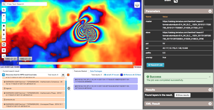
Figure 1. Differential interferogram covering the period 16 December 2016 to 28 January 2017. Each fringe (colour cycle) represents 2π radians of phase change in the line-of-sight direction.
Figure 2 shows a coseismic interferogram for the 3 April 2017 Botswana earthquake formed by combining two Interferometric Wide Swath Sentinel-1 images acquired from ascending relative orbit 14 between 30 March and 11 April 2017. The deformation pattern shows a lobe oriented NW-SE where ground moves away from the satellite and the opposite movement to the southwest. This is consistent with surface deformation produced by a NW-SE striking normal fault, dipping to the NE, as suggested by Kolawole et al. (2017).
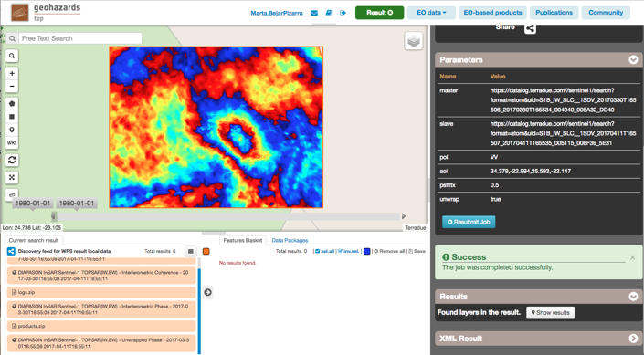
Figure 2. Coseismic interferogram for the Moiyabana earthquake (Botswana) formed by combining two Sentinel-1 acquisitions: 30 March and 11 April 2017.
These and other case studies were used during the training in Ethiopia to illustrate how InSAR and Sentinel-1 data can be used for ground deformation monitoring, complementing other techniques used by the African Geological Surveys to respond to earthquakes, volcanoes and other deformation phenomena.
References:
Kolawole, F., E. A. Atekwana, S. Malloy, D. S. Stamps, R. Grandin, M. G. Abdelsalam, K. Leseane, and E. M. Shemang (2017). Aeromagnetic, gravity, and Differential Interferometric Synthetic Aperture Radar analyses reveal the causative fault of the 3 April 2017 Mw 6.5 Moiyabana, Botswana, earthquake, Geophys. Res. Lett., 44, doi:10.1002/2017GL074620.
Xu, W., Rivalta, E. and Li, X.(2017). Magmatic architecture within a rift segment: Articulate axial magma storage at Erta Ale volcano, Ethiopia, Earth and Planetary Science Letters 476 (2017) 79–86.