A Red Alert has been declared in southern Chile after the eruption of the Villarrica volcano early on 3 March. Thousands of residents in the area have been evacuated and the International Charter Space & Major Disasters has been activated by Chile's risk management authority ONEMI.
Further to the operational support provided by the Charter, ESA and the German Remote Sensing Data Center of DLR have teamed up to acquire and process Sentinel-1A imagery illustrating changes at the surface of the volcano.
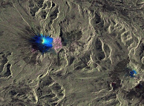
The image shows a color composite of the activeVillarrica Volcano based on pre-event (20/02/2015) and post-event (04/03/2015) Sentinel-1 SAR imagery. Changes are visually enhanced by a Normalized Change Index and statistical computations. Blue colors are correlated with a backscatter increase and magenta colors with a backscatter decrease between pre- and post-event data. Areas of no change between the two acquisitions appear in greyish colors.
The summit of Mount Villarrica is covered by a glacier. The change map shows the volcano dominated by blue colors, i.e. marking an increase of the radar backscatter. This effect can be explained by melting of snow and ice due to the increase of the temperature caused by the volcanic eruption on 03/03/2015. Prior to the eruption the radar backscattering was relative low as the surface was completely covered by snow; whereas after the snow and ice melting the surface roughness and therefore the radar backscattering increased.
At the eastern flank of the volcano one recognizes cyan colors. In this area the surface roughness strongly increased. The reason for this may be melting of snow and the accumulation of large volume of volcanic material (volcanic ash, lava flows and tephra). For instance, the cyan line reaching from the crater down along the southeastern flank maps a lava flow.
The area east of the volcano is dominated by magenta colors, i.e. marking a decrease of the radar backscattering. The reason for this may be accumulation of volcanic ash in this area. The volcanic material was mainly accumulated at the eastern side of Villarrica Volcano (cf. above). Due to the ash accumulation in this area the surface got smoother and therefore the radar backscatter decreased.
This interpretation was not validated in the field and contains assumptions.
This work was performed by DLR in the framework of the ASAPTERRA project originated by ESA.
Sentinel-1A is the first satellite for Europe’s Copernicus programme. With its radar vision, the Sentinel-1 mission provides an all-weather, day-and-night supply of imagery of Earth’s surface. Although not yet in routine operations, Sentinel-1A currently provides a coverage every 12 days of relevant tectonic areas worldwide and is therefore very suitable to monitor events such as volcanic eruptions.