FASTVEL, a service for the precise measurement of surface displacements from a stack of SAR satellite images, has been integrated by TRE-ALTAMIRA into GEP, and is part of the Services Catalogue of the GEP v2 release.
The service is based on Persistent Scatterers DInSAR techniques, to analyse a stack of differential interferograms and extract the terrain displacement information out of it. FASTVEL employs Sentinel-1, ENVISAT ASAR and ERS data products.
Two processing modes can be selected:
- IFG, to generate a stack of differential interferograms
- MTA, to generate a mean velocity displacement map
Thought to maximize automation, few parameters (default values are proposed in any case) can be tuned by the user in order to adapt the datasets to the Area of Interest properties.
Examples of FASTVEL results can be found in the images below, showing an interferogram over the island of Fogo, Cabo Verde (Figure 1) and a mean displacement velocity map over the mining area of el Bages in Catalonia, Spain (Figure 2).
FASTVEL is aimed at providing to the community an agile tool for identifying and quantifying displacement episodes, and for the evaluation of their extent and magnitude.
A limited number of licenses is initially available for the usage of FASTVEL. User requests for accessing the service will be evaluated with the provider TRE-ALTAMIRA.
You can contact us by replying to this topic, or by emailing to the ‘contact’ link here.
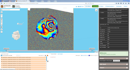
Figure 1 - FASTVEL interferogram over the island of Fogo (Cape Verde). The extent of this measurement is approximately 20 km
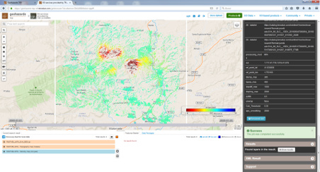
Figure 2 - Mean displacement velocity map over the mining area of el Bages in Catalonia (Spain). The extent of this measurement is approximately 25 km