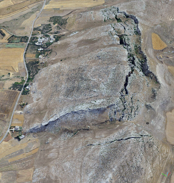
The Chgega Landslide, in northern Tunisia, represents an outstanding mass movement because of the particular landscape it creates.
The landslide involves a great block of limestone —about 900 m long and 400 m wide— sliding over ductile clays and marls. The viscoplastic creep of the clays drives the landslide and creates, in its crown, a graben ~800 m long and ~120 m wide that breaks the summit of the Chgega Mountain. Using the P-SBAS service of GEP, it has been demonstrated that this complex landslide is currently active, and moreover shows progressive movement without clear episodic accelerations. Adjusting the parameters in GEP, we were able to measure the velocity of the landslide in just above 2 mm/yr. To do so, we ran several preliminary processing trials with the following objectives: to check if the slope was in motion in the analyzed period of time and if so, to know the approximate velocity of the movement, and finally, to fine-tune the processing. When we found that Chgega landslide appeared to be in motion but at a very-low velocity—because we were able to recognize the pattern of the movement, but below the common error range of this kind of analysis with Sentinel-1 images (i.e., ±5 mm/yr)—we decided to increase the precision of our measurements through two strategies: (1) selecting a reference point close to the landslide that showed great coherence and stability; and (2) defining a high coherence threshold. Thus, we reduced the error range to ±2 mm/yr, increasing the sensitivity of our analysis.
The rapid processing performance of GEP was well suited to make these adjustments. We checked different numbers and combinations of images in order to improve the quality of the results. GEP greatly facilitated our work.
This characterization of the Chgega landslide can serve as the basis for future studies about the origin of this dramatic slope movement.
The results of the investigation has just been published in the journal Remote Sensing.
If you want to get more information about this case please contact jpgalve@ugr.es or c.reyes@igme.es.