On 14-08-2021, a Mw 7.2 earthquake hit Haïti. This event was followed by a few days of heavy rains triggered by tropical depression Grace. The combination of these extreme phenomena triggered a large number of landslides in the hilly region of Haïti, especially in the region of the Pic Macaya National Park.
On 23-08-2021 a cloud free Pléiades image (acquired by the international Disaster Charter) and the CIEST2 programme of CNES covering the zone affected by a high density of landslides allowed us to conduct a nearly fully automatic mapping.
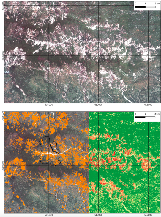
Figure 1: Landslide detection with ALADIM-VHR in single-date mode, for which only a post-event image is used. Top: Fusion of P (panchromatic) and MS (multi-spectral) Pléiades image of 23-08-2021. Bottom: Detected landslides (left) and probability of accurate detection (right).
A first analysis (Figure 1, Figure 2) has been carried out only using a post-event Pléiades dataset which includes a multispectral image (spatial resolution of 2m) and a panchromatic image (spatial resolution of 0.7m) covering an area > 350 km2. A training sample of a few landslides has been created manually for a very small portion of the affected zone (e.g. 4 km2 out of an area of more than 350 km2 for the full image). This sample is used to train a machine learning change detection model (e.g Random Forest) to predict landslide locations (and the confidence of accurate detection) over the full region of interest from a series of radiometric, textural and topographic features.
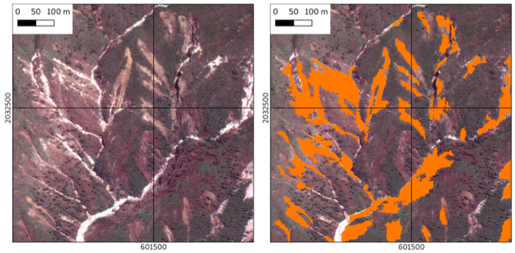
Figure 2: Zoom on the detected landslides with ALADIM-VHR in single-date mode. Left: Fusion of P (panchromatic) and MS (multi-spectral) Pléiades image of 23-08-2021. Right: Detected landslides.
The surface of detected landslides is about 45 km2 (ca. 13% of the area of interest) and very small landslides of sizes < 500 m2 could be identified.
A second analysis (Figure 3) has been carried by using a pre-event Pléiades images acquired on 25-12-2015. The overlapping between the 2021 and the 2015 image concerns an area of ca 100 km2.
The ALADIM-VHR service in bi-date mode (pre-event and post-event images) is used to increase the quality of the detection. The use of the bi-date mode allows to detect only the landslides directly triggered by the Mw 7.2 earthquake and by Grace, and not the full population of landslides. It further allows to better delineate the shape of the landslides, and avoid false detection (e.g. sediment deposits in the river channels, objects with high reflectance). Over the overlapping zone of 100 km2, the surface of the detected landslides is about 7 km2 (ca. 7% of the area of interest).
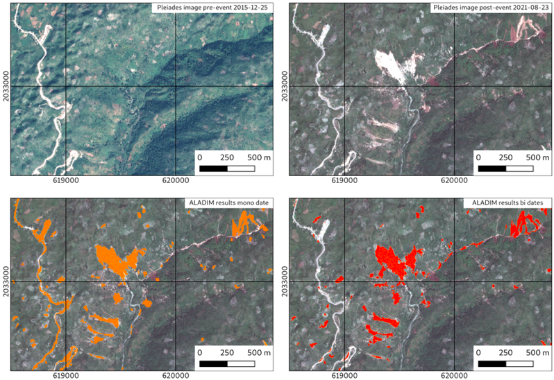
Figure 3: Landslide detection with ALADIM-VHR in single-date mode (left) and bi-date mode (right). Top left: Fusion of P (panchromatic) and MS (multi-spectral) Pléiades image of 25-12-2015. Top right: Fusion of P and MS Pléiades image of 23-08-2021. Bottom left: Detected landslides with ALADIM-VHR in single-date mode. Bottom right: Detected landslides with ALADIM-VHR in bi-date mode.
Results are public and can be accessed here for the ALADIM-VHR single-date mode and here for the bi-date mode. Click on “Show results” at the bottom of the right panel to see the generated landslide inventories not filtered.
This work was supported by CNRS-EOST, CNES and ESA.
Aline Déprez, Julien Jean-Baptiste and Jean-Philippe Malet