End of 2019 was particularly damaging in some Eastern African countries due to the heavy rains which triggered numerous mass movements. Extremely heavy rainfall were recorded in West Pokot County (Kenya) on 23 and 24 November 2019. An official from the West Pokot county government indicated that 53 people died from the huge landslides while several roads in the valley have been affected and at least 5 bridges were reported as destroyed The landslides were detected from a combination of high-resolution Sentinel 2 images and very high-resolution Pléiades images acquired before and after the landslide catastrophe with the engagement of the UNOSAT’s rapid mapping service which activated the 'International Charter 'Space and Major Disasters’. In combination to this effort, science-driven landslide inventories were created by CNRS-EOST with the ALADIM change detection algorithm available on the ESA GeoHazards Exploitation Platform.
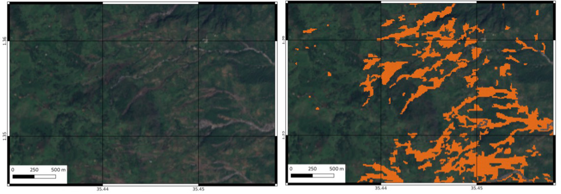
The automated change detection processing service ALADIM-S2 for High-Resolution imagery was initiated early December 2019 using a post-event cloud-free Sentinel-2 image available on November 28, 2019 and a pre-event Sentinel-2 image acquired on September 19, 2019. The processing used as input a small reference training dataset of a few landslides digitized over a region of interest of ca. 400 km2. The ALADIM-S2 processing allows the detection of nearly 6000 landslides representing 18 km2 of affected lands for a density of ca. 5%.
The activation of the ‘Space and Major Disasters’ charter protocol and the support of the CIEST ‘Cellule d’Intervention et d’Expertise Scientifique et Technique’ from CNES and INSU for the science-driven analysis of the data available allowed refining the inventory with the use of a set of Very-High-Resolution Pléiades images lover the area identified with the highest landslide density. For the CIEST processing, only one Pléiades post-event image was available. 170 landslides were manually digitalized over a region of interest of ca. 31 km2. The ALADIM-VHR processing allows mapping nearly 5500 landslides representing 3.9 km2 of affected lands for a density of ca. 12 %. By comparison to the Sentinel-2 dataset over this area, 1041 landslides were detected by the ALADIM-S2 processing associated with a total surface of 3.4 km2.

Results are public and can be accessed by following this link for the Sentinel-2 processing and this link for the Pléiades processing. Click on “Show results” at the bottom of the right panel to see the generated landslide inventories not filtered.
This work was supported by CNRS-EOST, UNITAR, ESA and CNES.
Aline Déprez, Romy Schlögel and Jean-Philippe Malet