Nile Delta is historically targeted for various types of human activities and life needs since the Pharaohs’ era. This is mainly due to its wealth in terms of fresh water, flat fertile soils, recreation places, mineral resources, coastal lakes and fish farming. This attracted an excessive increase in population, civilization and accompanied developmental plans to accommodate such population growth.
Recently, land subsidence of the northern delta has become a topic of major concern to the Egyptian population and government. Land subsidence phenomena have major impact on infrastructure hampering further developments in the area. The situation becomes critical when the impact of climate change is addressed. With an average elevation of approximately 1 m above sea level within 30 km of the coast and a predicted rise in sea level, subsidence and coastal flooding of the northern delta has become a topic of major concern.
In the present work we utilize SNAPPING service on the Geohazards Exploitation Platform (GEP) to monitor the spatial and temporal patterns, as well as the magnitudes of urban land subsidence in the Nile Delta. We are aiming to explore and document the potential of Earth Observation platform-based solutions as an operational tool for measuring and monitoring land subsidence at millimeter level accuracy over wide areas such as the whole Nile Delta.
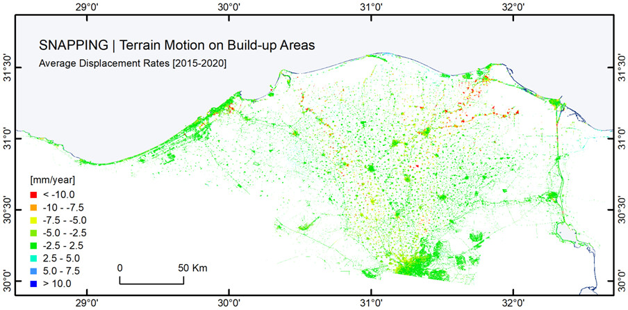
Average terrain motion for build-up areas of the Nile Delta from SNAPPING service on GEP using Copernicus Sentinel-1 mission for the period 2015-2020. Build-up areas were obtained from the ESA WorldCover 2020. WorldCover provides a global land cover product at 10 m resolution based on Sentinel-1 and 2 data.
The investigation is supported by ESA Network of Resources (NoR) sponsorship, involving the National Authority for Remote Sensing & Space Sciences (NARSS) of Egypt, the Aristotle University of Thessaloniki (AUTh) in Greece and the French Geological Survey (BRGM). Professor Islam Abou El-Magd, vice president of NARSS and Counselor for the Minister of Higher Education and Scientific Research of Egypt says “This is the first time that measurement of terrain motion is being attempted in a comprehensive way over the entire Nile Delta, a fact that will allow us understand and characterize the various on-going subsidence phenomena” .
The investigation results will be presented at the ESA Living Planet Symposium 2022.