Optical image correlation is a powerful geodetic tool for the analysis of terrain motion using optical satellite data. GEP is offering the new service MPIC-OPT-ETQ targeting the use of pairs of Copernicus Sentinel-2 images for near-field earthquake ground deformation.
The service allows to query the Sentinel-2 catalogue, select the combination of images, perform image matching using sub-pixel image correlation with the MicMac open source library (Rosu et al., 2015), apply geometrical and sensor correction (destripping, jitter; Stumpf et al., 2018), apply filtering criteria, visualize and download the results. The service is robust and forward and backward time direction matching can be applied in order to increase the signal to noise ratio. The technique is sensitive to horizontal motion and can measure sub-pixel deformation at up to 1/10th of the pixel size, hence up to one meter for Sentinel-2.
Post-seismic deformation can be retrieved mostly for earthquakes with strike-slip focal mechanism as illustrated with the examples of the Rigdecrest earthquake sequence in July 2019 and the Palu/Sulawesi earthquake of September 2018.
The Ridgecrest sequence refers to two main earthquakes that occurred in Southern California on July 4 and 6, 2019 with main shocks of magnitude 6.4 and 7.1. The sequence ruptured a complex system of conjugate faults with dextral slip on the NW-SE rupture and sinistral slip on the NE-SW rupture that can be identified in the outputs of MPIC-OPT-ETQ (Figure 1).
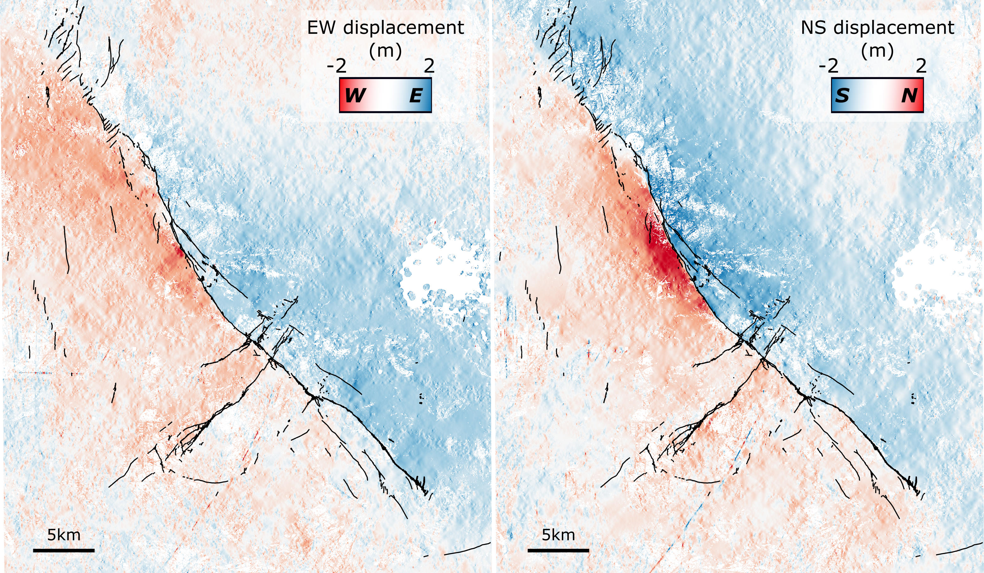
Figure 1: East-West (left) and North-South (right) displacement fields for the co-seismic deformation of the Ridgecrest sequence. The fault rupture is represented in black lines from Ponti et al. (2020). The displacement fields are computed with MPIC-OPT-ETQ with Sentinel-2 acquisitions of June 28, 2019 and July 7, 2019 on GEP and results can be found here.
The Palu/Sulawesi earthquake impacted the Sulawesi island (Indonesia) on September 28, 2018 with a magnitude 7.5. The mainshock ruptured a NNW-SSE left-lateral fault known as Palu-Koro Fault (PKF). The rupture is clearly visible in the North-South displacement field (Figure 2) with displacements up to 6 m.
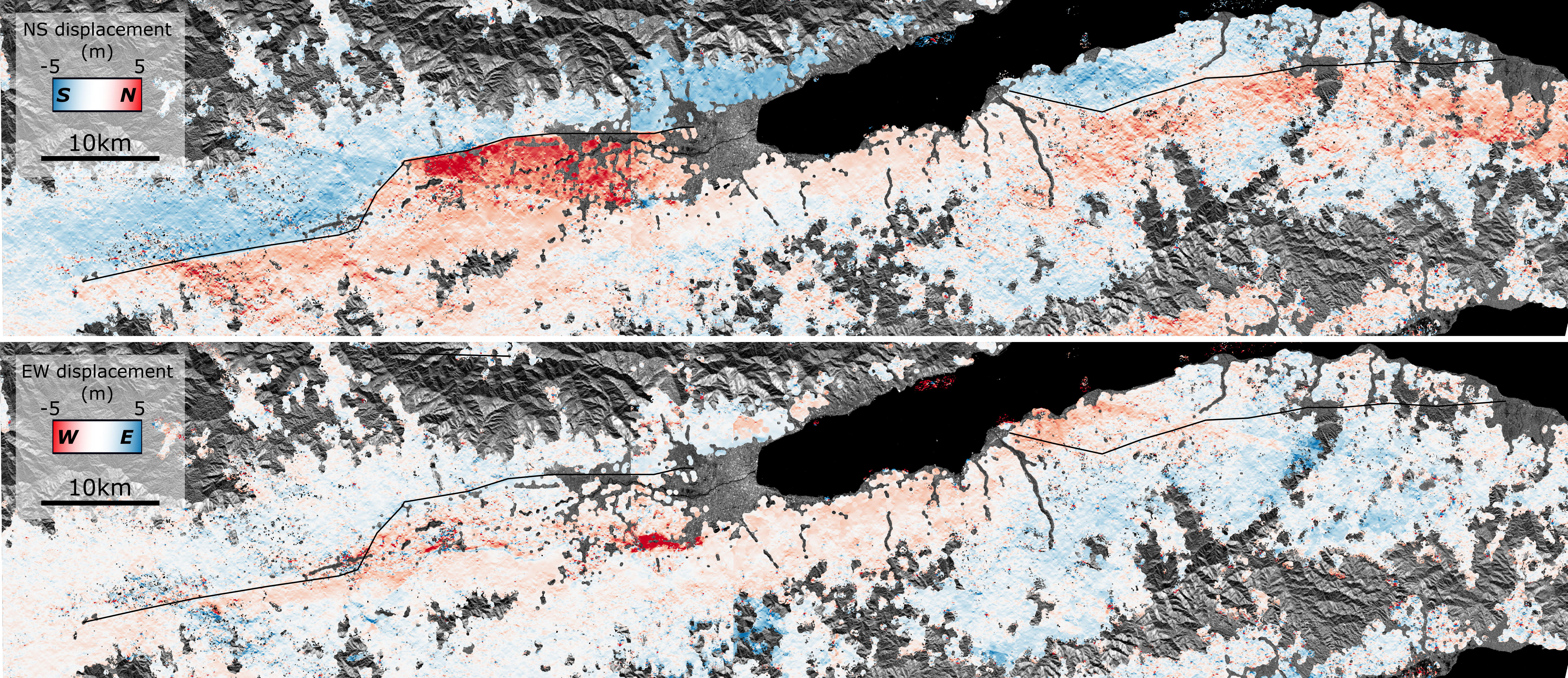
Figure 2: North-South (top) and East-West (left) displacement fields for the co-seismic deformation of the 2018 Sulawesi earthquake. The fault rupture is represented in black lines. The displacement fields are computed with MPIC-OPT-ETQ with Sentinel-2 acquisitions of September 17 and 27, 2018 and October 2 and 22, 2018 on GEP and results can be found here.
The service is developed and maintained by EOST/CNRS (Strasbourg) with contributions of IGN/Matis (Marne-la-Vallée), IPGP (Paris), European Space Agency (Frascati) and Terradue (Roma). The calculations are performed on the A2S High-Performance Computing infrastructure hosted at the Datacenter of University of Strasbourg, federated with the GEP, and part of the DataTerra/ForM@Ter Research Infrastructure. User requests for accessing the service are evaluated by the GEP Team and EOST/CNRS. You can contact us by replying to this topic, or by emailing to the GEP contact or the service maintainer.
