A large earthquake of magnitude 7.4 according to the Japanese Meteorological Agency (JMA) hit north-east Japan on March 16, 2022, at 23:36 JST, almost 60km off the coast of Fukushima.
About an hour and a half later, a first tsunami occurred along the coastline of Japan’s Miyagi prefecture, measuring 20 cm, according to the Meteorological Agency. Another wave measuring 30 cm was followed at 02:14 local time. Due to the hypocentral depth (57 Km) the earthquake did not generate a large tsunami but little uplift of the seafloor that caused small displacements of seawater.
USGS interpret this shallow-focus earthquake as a result of reverse faulting at a depth of 57 (JMA) or 63.1 km (USGS) within the Pacific Plate, suggesting a focal mechanism of a fault plane striking north northeast–south southwest, finally producing a maximum slip of 1.9 meters.
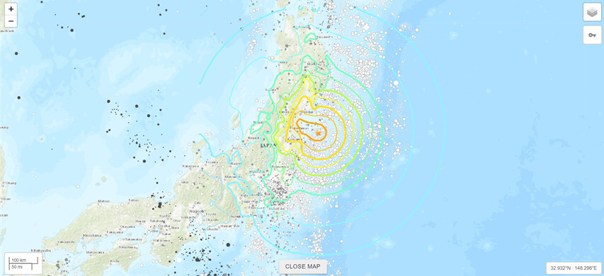
Figure 1. 2022 Fukushima Earthquake ( USGS )
The quake hit off the coast of Japan’s eastern Fukushima prefecture, a region devastated by a powerful quake and tsunami 11 years ago that resulted in a nuclear power plant meltdown. The 2011 Japan earthquake was 9.1 magnitude, some 63 times stronger, and released about 500 times more energy, resulting in the worst nuclear disaster since the 1986 Chernobyl incident. More than 22,000 were killed or went missing in that disaster. Deaths were caused by the initial earthquake and tsunami and by post-disaster health conditions caused by the radiation leak (CNN).
DInSAR measurements indicate small surface deformation following the earthquake, with evident lack of interferometric fringes (relative deep event). Ground displacements varies between 1-3 cm within the epicentral area, reaching locally -5 cm. Although not much deformation appears to have reached the surface, yet the 2022 Fukushima earthquake resulted in 4 fatalities and 225 injuries.
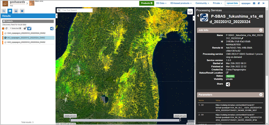
Figure 2: Ground deformation results using the GEP P-SBAS service for the acquisition dates 12 and 24 March, 2022. Contains modified Copernicus Sentinel-1A mission data (2022), processed by AUTh on GEP.
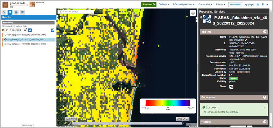
Figure 3: Localized maximum displacement close to the epicentral area highlighted in Figure 2.
The interferometric analysis was performed using the GEP P-SBAS processing service (IFG mode), containing Copernicus Sentinel-1A mission data with pre- and post-seismic acquisition dates on 12 and 24 March, 2022, accordingly (Descending Track 46).
Results are publicly free on GEP here.