To address the needs of the Haitian community involved in recovery and rehabilitation after the impact of Hurricane Matthew (category 4) on 4 October 2016, the Committee on Earth Observation Satellites (CEOS) triggered the 4 year-long Recovery Observatory (RO) project (https://www.recovery-observatory.org), aimed to demonstrate the value of using satellite EO to support recovery from a major disaster, and to work with the recovery community to define a sustainable vision for increased use of EO to this purpose.
Within this framework, the researchers of the Italian Space Agency (ASI) are testing the GEP to demonstrate its usefulness to generate satellite-derived thematic products based on SAR change detection (e.g. radar amplitude change and coherence maps), as well as Interferometric SAR (InSAR) for ground motion monitoring (e.g. differential interferograms, and time series).
A multi-temporal analysis of ground deformation has been recently carried out in GEP using the Parallel SBAS (P-SBAS) Interferometry Chain developed by CNR-IREA. Follow this link and click on “Show results” at the bottom of the right panel to see the generated ground deformation map and time series.
A long data stack of 63 Sentinel-1 IW TOPS SLC scenes acquired in 03/12/2016-28/04/2019 along descending track T142 over the Haiti RO area of interest was used, spanning the whole region most affected by Hurricane Matthew, encompassing the 3 departments of Grand’Anse, Sud and Nippes.
More than 26,400 coherent targets were identified with P-SBAS, with LOS velocities generally in the range of ± 3 mm/year but as high as -40 mm/year in localised sectors, indicating movement in the direction away from the satellite sensor and therefore presence of unstable ground. The results are currently been analysed by ASI researchers to enhance the knowledge on surface processes occurring in Haiti, in the context of the field evidence and ground truth that they directly gathered during the technical surveys carried out in mid-2019 together with partners from Centre National de l’Information Geo-Spatiale (CNIGS) de la Republique d’Haiti and Centre National d’Études Spatiales (CNES).
The geohazard information produced in GEP with the P-SBAS service is valuable to help the end-users in their decision-making processes and recovery progress monitoring after the disaster.
Moreover, while the whole SAR processing workflow could have been done on local processors, one of the crucial goals of the RO team is to design a data analysis chain working on the GEP with hosted processing services and resources, and therefore transferrable to the Haitian partners. To this aim, CNES is also coordinating a capacity building plan, including effective knowledge transfer of SAR and optical image handling and interpretation skills to the Haitian partners.
In this regard, preliminary results of Sentinel-1 derived products generated in GEP have already been presented by the Haiti RO team at ESA Living Planet Symposium 2019 and during the 3rd Users Workshop in Haiti in Jérémie on 30th April 2019, and in Port-au-Prince on 2nd-3rd May 2019. These results include trials of change detection by comparing pre- and post-Matthew Sentinel-1 data, and using other Sentinel-1 processing services available in GEP, such as SNAP Sentinel-1 IW SLC Interferogram and Displacements , SNAC - SNAP S1 GRD Amplitude Change developed by ESA, and FASTVEL developed by TRE-ALTAMIRA.
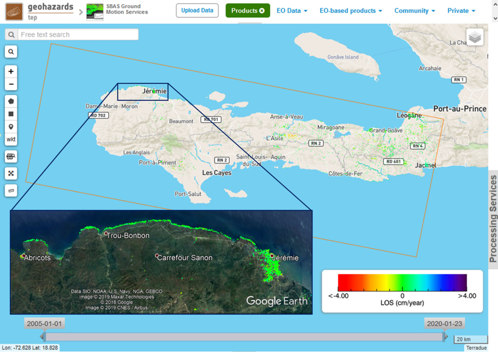

Sentinel-1 ground deformation map at 90 m. resolution over the CEOS Recovery Observatory in Haiti based on multi-temporal interferometric processing of Sentinel-1 2016-2019 data using the GEP P-SBAS processing on-demand service by CNR IREA. Copyright: Contains modified Copernicus Sentinel data (2019), processed by GEP, CNR-IREA & ASI.