Saltwater intrusion and land subsidence destroy northern Nile Delta archaeological sites: An assessment using hydrochemical indices, SAR satellite imagery, and analytic hierarchy process (AHP)
Mohammed Hagage (a), Abdel Galil A. Hewaidy (b), Abdulaziz M. Abdulaziz (c)
(a) Engineering Applications and Water Division, National Authority for Remote Sensing and Space Sciences (NARSS)
(b) Geology Department, Faculty of Science, Al-Azhar University
(c) Faculty of Engineering, Cairo University, Egypt
Archaeological sites in deltaic regions face increasing environmental threats. This study provides the first assessment of seawater intrusion and land subsidence impacts on archaeological sites in the Nile Delta through hydrochemical investigations, InSAR techniques, and multi-criteria decision analysis of 33 sites.
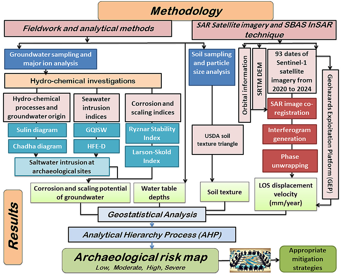
Study method assessing saltwater intrusion and land subsidence risks
The results reveal that 80.7% of groundwater samples are of the seawater NaCl single bond type, with northern groundwater primarily consisting of old marine water. The Groundwater Quality Index for Seawater Intrusion shows that 54.6% of sites have saline groundwater and 45.4% have mixed groundwater. Hydrochemical Facies Evolution analysis indicates that 73% of sites are north of the freshwater-seawater interface, with water tables <1 m deep. All sites show high risks of limescale accumulation and corrosive conditions.
SBAS-InSAR analysis (2020–2024) detected displacement velocities between −16 and + 5 mm/year, with maximum subsidence in the northern region.
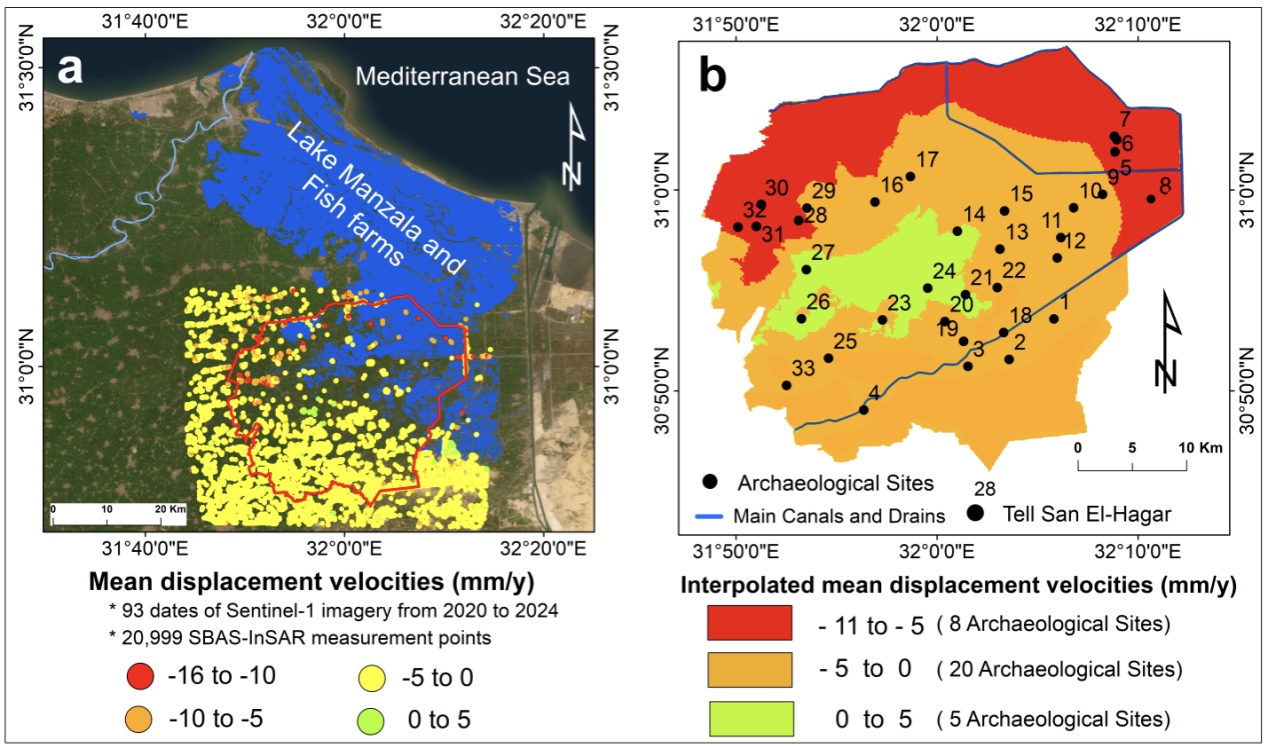
(a) spatial distribution of mean Line-of-Sight (LOS) displacement velocities (mm/year) derived from SBAS-InSAR processing of Sentinel-1 data (2020-2024). Negative values indicate subsidence, while positive values represent uplift. (b) Interpolated map of mean LOS velocities generated through Kriging of SBAS-InSAR measurement points. This map provides continuous coverage of displacement rates across the study area, including regions where direct InSAR measurements were not available.
The archaeological risk map was developed using the AHP, integrating water corrosion indices, water table depth, soil texture, and subsidence rates. The map classified the archaeological sites into four risk categories: 8 sites were classified as severe risk, 12 sites as high risk, 11 sites as moderate risk, and 2 sites as low risk.
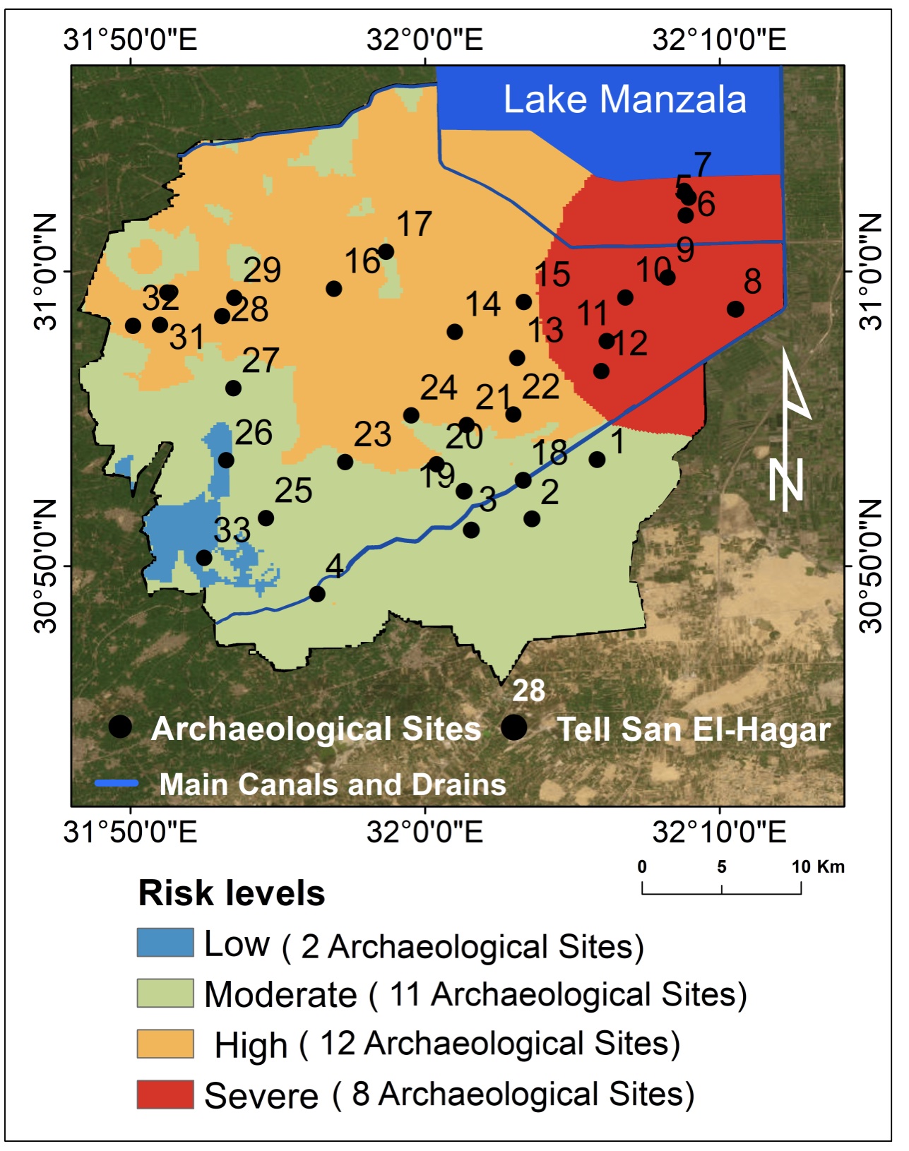
Archaeological risk map: Distribution of groundwater-induced deterioration risk levels. The risk categories represent potential groundwater-related damage to archaeological sites, assessed using the Analytical Hierarchy Process (AHP) method by integrating groundwater corrosion indices, water table depth, soil texture, and subsidence rates.
These findings highlight the urgent need for mitigation strategies, including groundwater level reduction and prioritized documentation of high-risk archaeological sites.
The Parallel Small Baseline Subset (P-SBAS) approach was employed to process the Sentinel-1 SAR scenes using the “CNR-IREA P-SBAS Sentinel-1 on-demand” service on the ESA Geohazard Thematic Exploitation Platform (https://geohazards-tep.eu).
The authors gratefully acknowledge the support of the European Space Agency (ESA), as this research was conducted under project ID 3b11cK, supported by the ESA Network of Resources initiative. We extend special thanks to Dr. Hervé Caumont for his exceptional technical support throughout our work on the Geohazards Thematic Exploitation Platform (Geohazards TEP).