Ground motion products for glaciers and landslides monitoring have been processed over the eastern Alps with the GEP services SNAPPING, GDM-OPT-ICE and GDM-OPT-SLIDE. The services were used to process the full archive of Sentinel-1 and Sentinel-2 for an AOI of 20,000+ km2 (Figure 1), and also for local scale landslide applications (1-5 km2). Together, they allow for monitoring very slow (0.005-0.1 m/year) and rapid (> 1 m/year) movement, giving a thorough overview of the unstable slopes (e.g. landslides, valley subsidence or glacier motions) in the Alps.

Figure 1: Spatial coverage of SNAPPING (ascending and descending) and GDM-OPT-ICE products.
Have a look by yourself ! The data are publicly available here and can be accessed through « Ground Motion Products > Digital Twin Alps > All » on the upper right menu.

Additionally, new tools have been implemented on the GEP geobrowser to visualize and interact with the time series online. It is now possible to plot the displacement time series for one point or one area, to plot the mean velocity and the elevation along transects, and also to change the scale and filter out points based on their velocity. This allows to explore online the complementarity of the two different monitoring techniques, giving an overview of the heterogeneity of motion taking place in the Alps, for instance around the Mont-Blanc glaciers (Figure 2). One can observe that the most active parts of the Mont-Blanc glaciers are well captured with GDM-OPT-ICE products (i.e. velocities ranging from 0.5 to 1 m/day) while SNAPPING products are scarcer where rapid displacement takes place due to loss of coherence. However, SNAPPING (with the processing of both ascending and descending satellite products), provides a rich dataset to document the stability of the slopes overhanging the glaciers, and also further downhill. The combination of both datasets, at local and regional scales, is believed to become a new standard for characterizing Earth surface motion related to surface processes in the future.
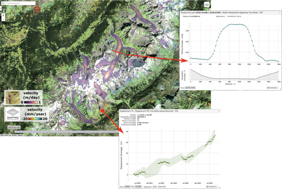
Figure 2: Examples of DTAlps outputs for surface motion over the glaciers of the Mont-Blanc massif computed with GDM-OPT-ICE (left) and SNAPPING (right). Note the difference of magnitude of the motion measured by the two data types (Sentinel-2, Sentinel-1) and approaches (Optical Image Correlation / OIC, and InSAR), and their spatial complementarity. Examples of the new tools provided by the geobrowser are also illustrated.
Credits:
The production of these results is part of the Digital Twin for Alps (DTA) demonstrator: an example of how Digital Twins will act as decision-making support platforms that will help us better understand complex physical processes and support applications for resources and disaster risk management. The goal of the DTA is to collect feedbacks from key stakeholders and users, in order to provide a roadmap for the implementation of a future Digital Twin Component of the ESA DTE. To do so, Sinergise, Sentinel-Hub, CNRS-EOST, CNR-Irpi, Terranum and MobyGIS, in collaboration with AUTh and Terradue, have implemented a demonstration platform in order to combine state-of-the-art developments in hydrology and geohazard sciences to represent, in a holistic way, the major environmental-related hazards and water resource impacts faced by populations living in the Alps.