When a disaster strikes, be it a devastating earthquake, a catastrophic flood, or a fast-moving wildfire, emergency responders need access to reliable, up-to-date information to act safely and effectively. The International Charter: Space and Major Disasters plays a vital role in this global effort by coordinating satellite-based Earth observation resources from multiple space agencies and making them available for disaster response worldwide.
Terradue is proud to contribute to this mission through the Disaster Charter Processing Environment, a cloud-based platform developed and operated by Terradue to support the Charter’s rapid response capabilities. Funded by the European Space Agency (ESA) under a contract with EVERSIS (Poland), the platform is designed to accelerate access to satellite data and provide powerful tools for real-time geospatial analysis and visualisation.
A Platform Supporting a Global Collaboration
The International Charter is a collaborative initiative involving 17 space agencies and dozens of partners across the globe. These organisations work together to provide free access to satellite data for use in humanitarian emergencies. Since its founding in 2000, the Charter has supported thousands of disaster events, from typhoons and tsunamis to landslides and volcanic eruptions.
While the Charter’s core mission is to make satellite data available, the challenge lies in turning that data into timely, actionable insights. That’s where the Disaster Charter Processing Environment comes in. Since 2020, Terradue has led the development of this platform, ensuring that data delivered through the Charter is processed, visualised, and made accessible to those who need it most: emergency services, civil protection authorities, and humanitarian organisations on the ground.
Designed for Speed, Scale, and Usability
Built on a modern cloud-native architecture, the Disaster Charter Processing Environment provides a scalable and highly available digital workspace. This enables the rapid ingestion, processing, and analysis of data coming from multiple Earth observation satellites, often within hours of a disaster alert.
The platform is engineered for automation and efficiency. It uses containerized processing pipelines (based on Docker and Kubernetes) to orchestrate workflows and manage resources dynamically. It automatically ingests satellite imagery from diverse sources—including radar and optical missions—and enables near-real-time processing to generate maps, overlays, and analytical products for disaster assessment.
Despite the complexity of the backend, the platform presents a user-friendly interface that is accessible to a broad range of users. Whether working in a national emergency operations center or in the field with limited connectivity, users can navigate the platform to extract the information they need—quickly and reliably.
Supporting a Diverse Set of EO Missions
The Disaster Charter Processing Environment connects to the ESA Charter Mapper, which supports data from over 40 Earth observation missions operated by 24 space agencies and data providers. This includes key missions such as:
- Sentinel-1 and Sentinel-2 (ESA)
- Pléiades NEO (CNES)
- Landsat-8 and Landsat-9 (USGS)
- ALOS-2 (JAXA)
- Amazonia-1 (INPE)
- Resourcesat-2 (ISRO)
- ICEYE, SAOCOM, TerraSAR-X, and more
By leveraging this broad catalogue of satellite data, the platform delivers the flexibility needed to respond to various types of disasters, providing both high-resolution imagery and long time-series data that can support rapid assessment and long-term recovery alike.
Terradue’s Role and Technological Expertise
Terradue brings to the project a long-standing expertise in cloud-based platforms for Earth sciences, developed over many years through ESA and European Commission initiatives. For the Charter, Terradue is responsible for the full lifecycle of the Processing Environment—from design and development to operations and continuous evolution.
Some of the platform’s technical strengths include:
- Multi-cloud architecture that ensures resilience and rapid scalability
- Automated ingestion and processing of multi-source EO data
- Geospatial visualisation tools for creating detailed maps and disaster products
- Big data storage using cloud-optimised infrastructure for fast retrieval
- Modular workflows that support integration of new datasets and processing chains
These capabilities ensure that the platform not only supports today’s disaster response needs but is also ready to evolve as new sensors, data types, and analytical techniques emerge.
A Human-Centered Mission
Behind every satellite image and every data layer processed through the Disaster Charter Processing Environment is a real-world impact. Whether it’s helping locate flooded communities, mapping fire perimeters, or assessing earthquake damage, the information delivered through this platform contributes to saving lives, protecting infrastructure, and aiding recovery.
Terradue’s contribution to the Charter is driven by this purpose. By building and operating the technological backbone that transforms Earth observation data into usable insights, we are supporting a mission that connects science, technology, and humanity in times of urgent need.
As the climate crisis intensifies the frequency and severity of disasters, platforms like the Disaster Charter Processing Environment will become even more critical. Terradue remains committed to pushing the boundaries of what’s possible with EO data processing and continuing to support global collaboration for disaster resilience.
Real-World Impact: Example Activations
Below are examples of real disaster events where the Disaster Charter Processing Environment helped transform raw satellite data into insights for emergency response teams.
Flood in Spain
1 Nov 2024
Charter Activation 924
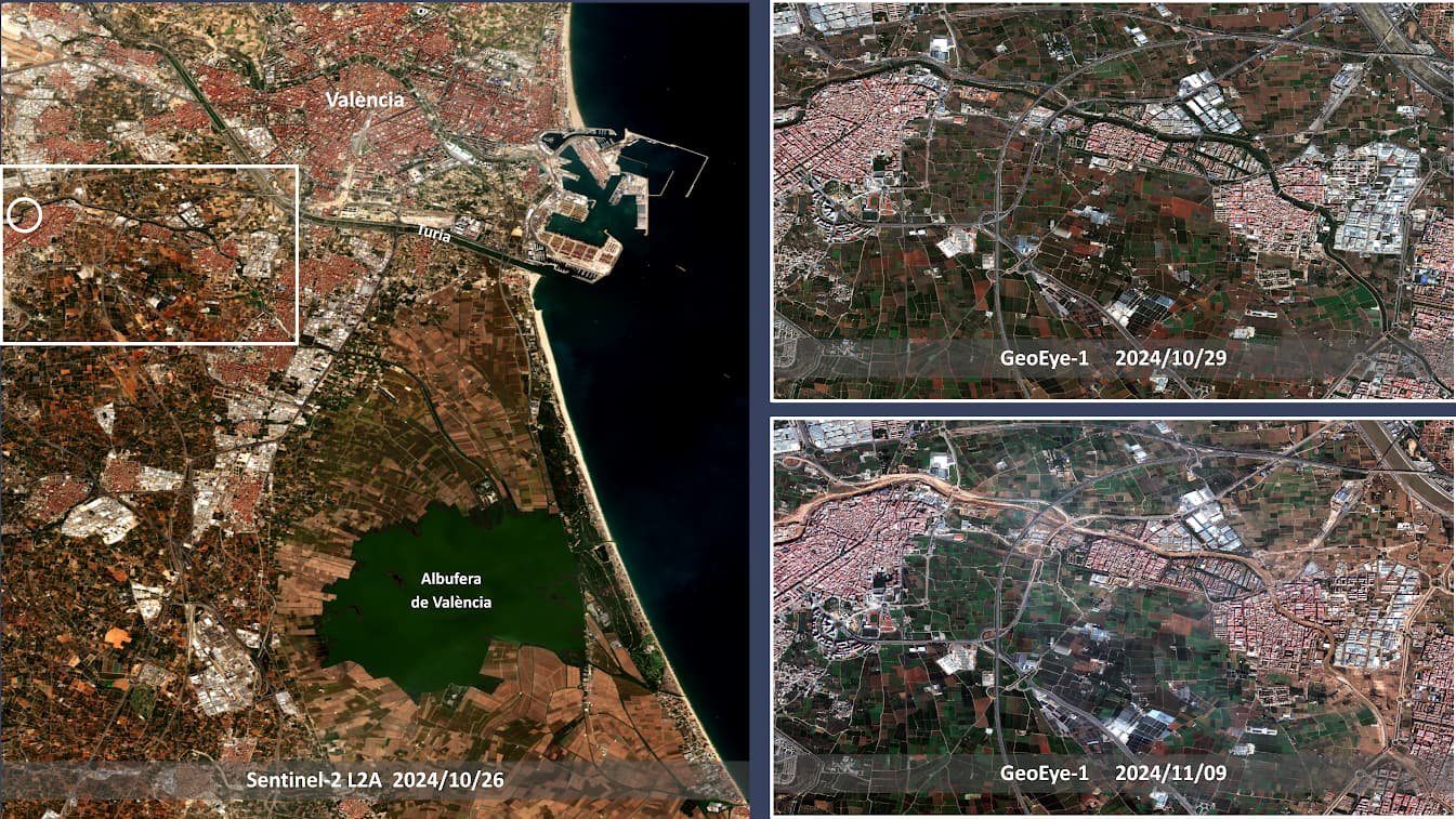
True color composites showing before and after the 2024 Spanish floods over Valencia. Images derived by the Charter Mapper from calibrated Sentinel-2 L2A data acquired over Valencia on 26 Oct 2024 (left) and from co-registered GeoEye-1 L1C data acquired on 26 Oct 2024 (top right) and 09 Nov 2024 (bottom right). © 2024 GeoEye, USGS. Contains modified Copernicus Sentinel-2 data (2024).
Earthquake in Türkiye
6 Feb 2023
Charter Activation 797
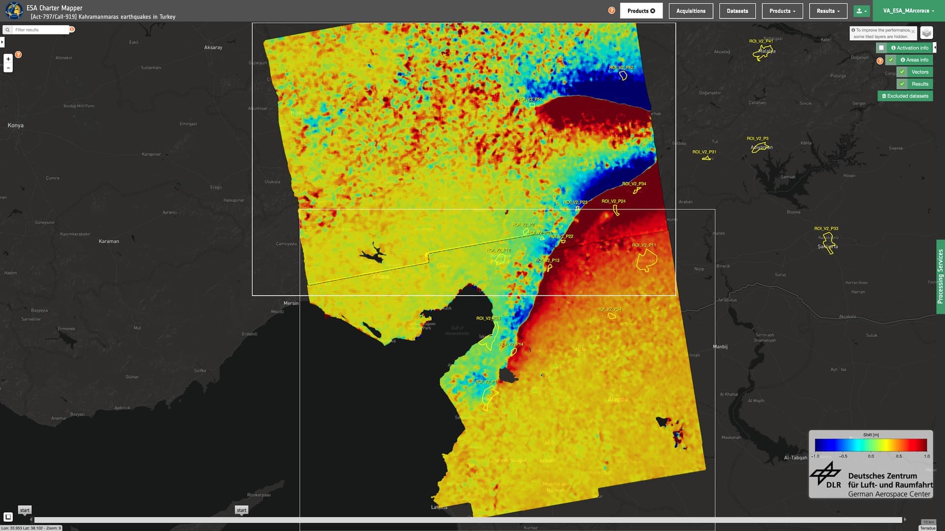
LOS deformation map over Türkiye and Syria generated in the Charter Mapper using the DLR InSAR Browse service from Sentinel-1 SLC data acquired on 9 February and 28 January 2023. Contains modified Copernicus Sentinel-1 data (2023).
Flood in Nigeria
15 Sep 2022
Charter Activation 777
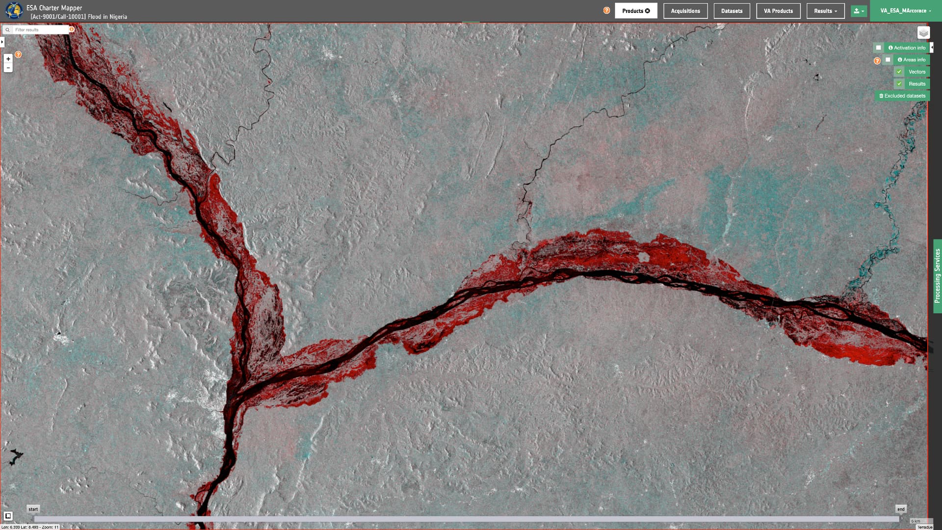
Red-Cyan backscatter composite showing in red flooded areas along the Benue and Niger rivers during the 2022 Nigeria floods. This product is generated in the Charter Mapper using the SAR-Change service from Sentinel-1 GRD data acquired on 26 August and 13 October 2022. Contains modified Copernicus Sentinel-1 data (2022)
Earthquake in Türkiye
6 Feb 2023
Charter Activation 797
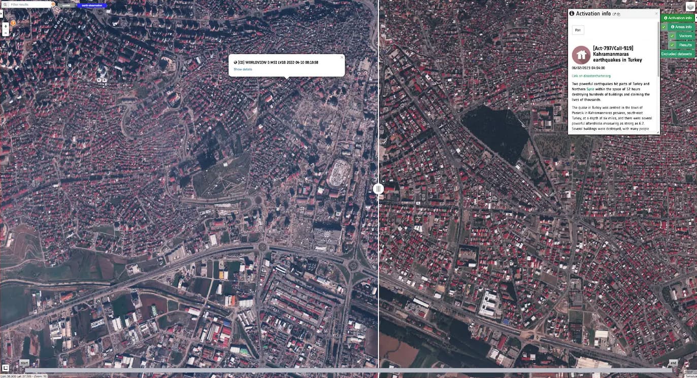
True color composites showing before and after the M 7.8 earthquake over Marash, Turkey. The post-event image on the left shows many collapsed buildings in the Marash city center. Images derived by the Charter Mapper from calibrated Worldview-2 L1C data acquired on 23 Feb 2023 (left) and on 10 Apr 2022 (right). Copyright: © 2022-2023 Maxar, USG Plus, USGS.
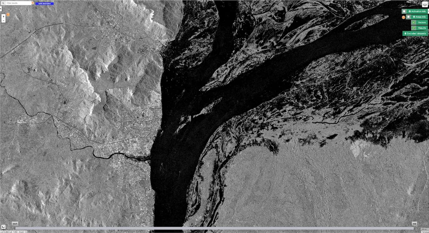
Radar backscatter from high resolution X-band SAR data in HH polarization showing in black standing waters near Lokoja during the 2012 Nigeria floods. Image derived from TerraSAR-X geocoded terrain corrected data acquired on 26 September 2012. Copyright: © DLR e.V. (2012), Distribution Airbus DS Geo GmbH.
Hurricane Beryl in Jamaica
2 Jul 2024
Charter Activation 893
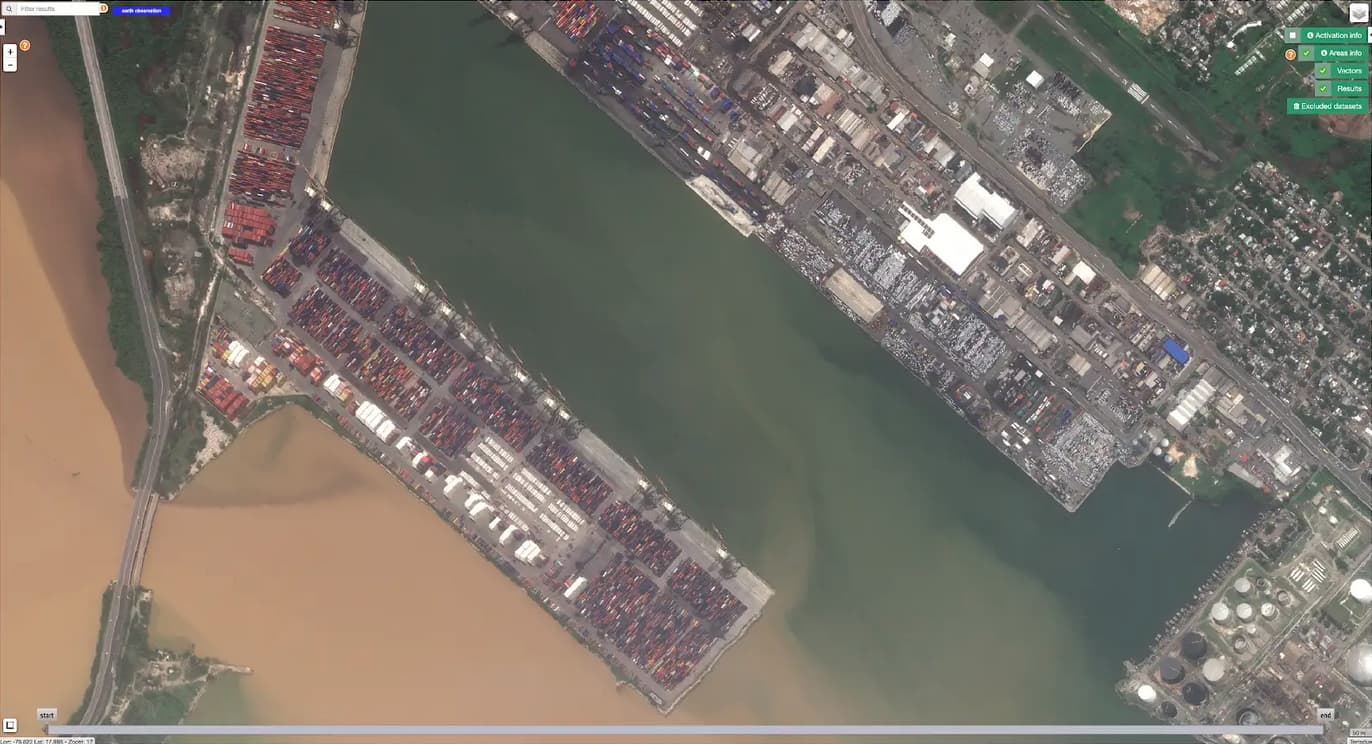
True color composites showing the situation in Kingston harbor after the landfall of Hurricane Beryl that hit Jamaica on the 3 July causing heavy winds and rainfall. Image derived by the Charter Mapper from calibrated Pléiades NEO orthorectified data acquired on 4 July 2024. Credits: Includes Pleiades NEO material © CNES (2024), Distribution Airbus DS.