Web-based platforms and collaborative projects are revolutionizing the way to analyze remote sensing data. Moreover, new Earth Observation (EO) missions provide accurate information in time and space, which constitute a significant amount of data waiting to be analyzed. To accomplish this task, web-based processing tools and user networks will take a leading role. The European Space Agency’s Geohazard Exploitation Platform (GEP) is a good example of the mentioned web-based platforms.
The paper published in Remote Sensing presents a detailed evaluation of the results produced by the SBAS InSAR service of the GEP in Spain. The analysis was not restricted to areas of previously known deformation, validating some points where the GEP results pointed to active deformation but no active processes have been described up to now. The article explores the trustworthiness and usefulness of the GEP by a research team independent to the developers of the SBAS InSAR service, complementing the work of Albano et al. (2016) in Mexico City.
The paper show how the GEP will help (1) to identify phenomena not yet documented; (2) to monitor known deformations; (3) to delineate precisely the areas affected by the processes that modify the Earth surface; and, (4) to forecast future acceleration of the movements or catastrophic ground failures. Several examples illustrate all of these cases: (1) A lateral spreading phenomenon not recorded in any landslide inventory or publication; (2) time-series collected in places affected by landslides and subsidence already documented; (3) areas affected by subsidence due to water extraction delimited with a reasonable precision; and, (4) the deformation in the Marina del Este resort that represents a precursor of the reactivation of a landslide in 2010.
Architects and engineers from Andalusia who work in spatial planning, infrastructure maintenance and legal issues in urban planning have expressed a keen interest in the paper. They see the GEP as a powerful tool (1) to avoid economic losses related to the purchase and sale of real estate and (2) to detect problems in infrastructures.
The paper is freely available at: http://www.mdpi.com/2072-4292/9/12/1291

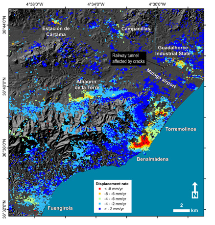
Surface velocity map produced by the GEP in the West of Malaga (Spain). Note the clear subsidence detected between the Benalmádena and Torremolinos municipalities not analyzed neither mentioned in press reports so far.