Hi all!
We just setup a forum to report experiences on the use of the optical services (MPIC, DSM-OPT, ALADIM) dedicated to ground deformation analysis (earthquakes, landslides).
Do not hesitate to report any successful or unsuccessful runs of the services, or any new functions that you would like to be implemented.
Hello to everyone,
I will summarize in few comments my experience using the ground deformation analysis tools from GEP.
ALADIM was added recently in my toolbox, but I havent found any description about the workflow (parameters, upload file formats etc) even outside GEP.
DSM-OPT tool; run a few test runs using the available sample datasets (Pleiades). However, a description of custom upload files is needed - native product zip format or separate files?
MPIC-OPT; As I used this tool a lot more than the other ones, I will offer more extensive comments and feedback about this. The two papers from Stupf et al. 2017/2018 offered some helpful insight into the processing chain, including my own experience in using MicMac for displacement analysis.
MPIC-OPT generally seems to work, with some exceptions that I will describe below, mapping ground displacement at a Sentinel-2 tile scale. Havent really tried time-series examples for landslide displacement, as my main focus was on co-seismic large horizontal displacements.
Positive/encouraging aspects:
Large area covered - full Sentinel-2 tile
Parameters on tool panel are kept quite simple and fast to use once familiar with the tool
Export includes multitude of file products, which is useful
Inverse matching is important, as in many cases there is observable difference in outcome
Disadvantages/problems:
There is an issue with Sentinel-2 single-tile compatibility. Some specific tiles (usually older than 2017 but some recent too) are incompatible and the tool fails. This must be related to some format issues at the GEP repository.
There should be an option to a) manually input some parameters and b) deactivate cloud masking. Most of the examples I ran, had the issue of cloud masking overkill: cloudless tiles over desert/arid areas had large parts missing due to erroneous masking, while in other scenes cloud masking removed urban-semi-urban areas that had no clouds or haze.
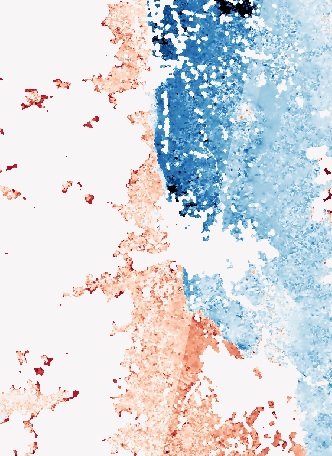
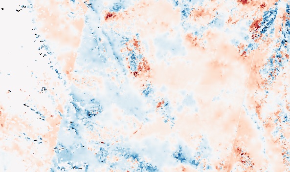
From the relevant publications, I’ve understood that MPIC-OPT uses the coregis process or a variant for scene pre-processing and correction (destriping/deramping). However, most runs had some visible artifacts, especially stripes. Deramping mostly worked on most cases - I run separately the same images using MicMac and usually there was a significant ramp present that needed correction, which wasnt present on MPIC-OPT products (although this could be an effect of better co-registration).
Some examples from Sentinel-2 tile and pushbroom artifacts in MPIC-OPT products:
Px2 RGB
Px2 RGB
As the Px1 / Px2 are the basic output products, there should be an option to convert in map units, or a description of how to do the conversion manually. Although I am familiar with this, few people do know in depth the MicMac/MM2DPosSism processing and they would find this trivial.
Hope to have offered some insight into the sucess and issues encountered using the optical ground deformation tools. I will post any new progress/issues as they come around.
I am a really recent user of G-TEP and have to test MPIC-OPT in Northern Norway as part of a ESA-funded project. I have not much experience in optical processing tools as my work is usually focusing on InSAR.
I am trying to follow the tutorials but got already some basic questions:
Do we have to manually go through all images to find ones with little cloud coverage, or is there a way to automatically filter out the heavily affected scenes?
I started to run a job with four S-2 inputs, but it is pretty slow, I guess because it is processing the full tile. Is there a way to select only a small AOI? I may have missed sth but did not find a tool/parameter field to do it. It could be a way to constrain the input to a similar footprint, as it seems to fail when not having the same extent.
The examples in MPIC-OPT tutorial are based on Level1C products? Is it actually better to use bottom-of-atmosphere products or it shouldn’t make any difference (correction applied in the chain)?
Sorry in case it is explained somewhere but I haven’t found.
Nice to have you on board for GEP …
For the images, you need to indicate the period of image acquisitions or select the images by yourself based on your own criteria. MPIC-OPT will integrate an image in the processing only for scenes with less than 30% of cloud coverage (based on the Copernicus S2 metadata).
MPIC-OPT has three steps: the fist step if the fine co-registration of the pile of S2 based on correlation techniques in order to deramp and destrip the images. This is done on the full tile. The second step is the correlation for motion estimation on the finely co-registered image. This is also performed on the full image. And finally, the third step is the stacking of the deformation measurements to identify relevant spatial and temporal deformation patterns.
Steps 1 needs to be performed on the full tile. I note the user request for Step 2 to be able then to define a ROI - we will implement this option in a further version of the service.
Level 1C products are sufficient to perform the processing. BOA products will not help since the image matching is performed on a texture transformation of the S2.
Looking forward to your results, and to discuss them if needed, and to possible other suggestions.
Thanks for your quick answer. I went further with 1C products and selected manually good scenes covering my AOI (much smaller than the full tile so the 30% criterion is not enough for me -> 10% clouds concentrated on my AOI would already be a problem).
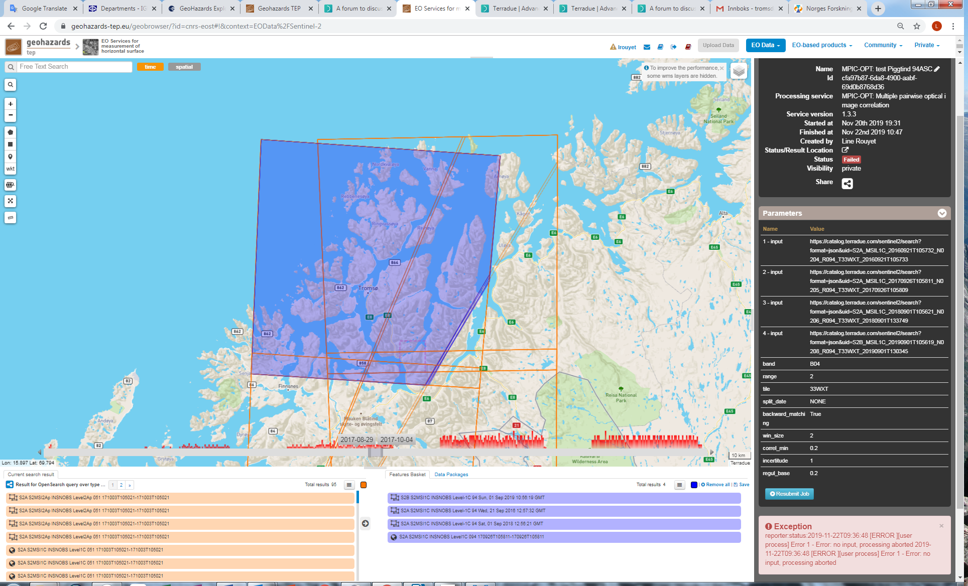
I had started a job on Nov. 20th, that was running until this morning, before to fail with the error message “no input, processing aborted”. This is odd cause I have of course added inputs (four S2 images from Sept. 2016-2019). So I guess sth was wrong in my selection? See print screen in attachment (pink rectangle is my AOI, blue-purple are the extent of the selected inputs, info about the job/error on the right side).
Sorry again if this is obvious, I am new both in the use of this platform and in the exploitation of optical satellite imagery.