Monday February 6, 2023, two large Mw7+ earthquakes struck Turkey and North-Syria. The first event occurred along the N60 striking East Anatolian Fault (EAF) and its prolongation towards the Dead Sea Fault, the N25 striking Karazu fault, with an epicenter 30 km south-east off the main rupture zone. The second event is located to the north of the first one, along the N100 Sürgü-Çartak fault. Focal mechanisms of both shocks exhibit a dominant left-lateral strike-slip component on sub-vertical faults. These ruptures and mechanisms are compatible with Anatolia westward extrusion between the North and East Anatolian faults in response to Arabia-Eurasia convergence. The complex geometry of the activated faults during this earthquake sequence sheds light on how strain is partitioned and distributed among the faults of this triple-junctions linking Nubia, Arabia and Anatolia.
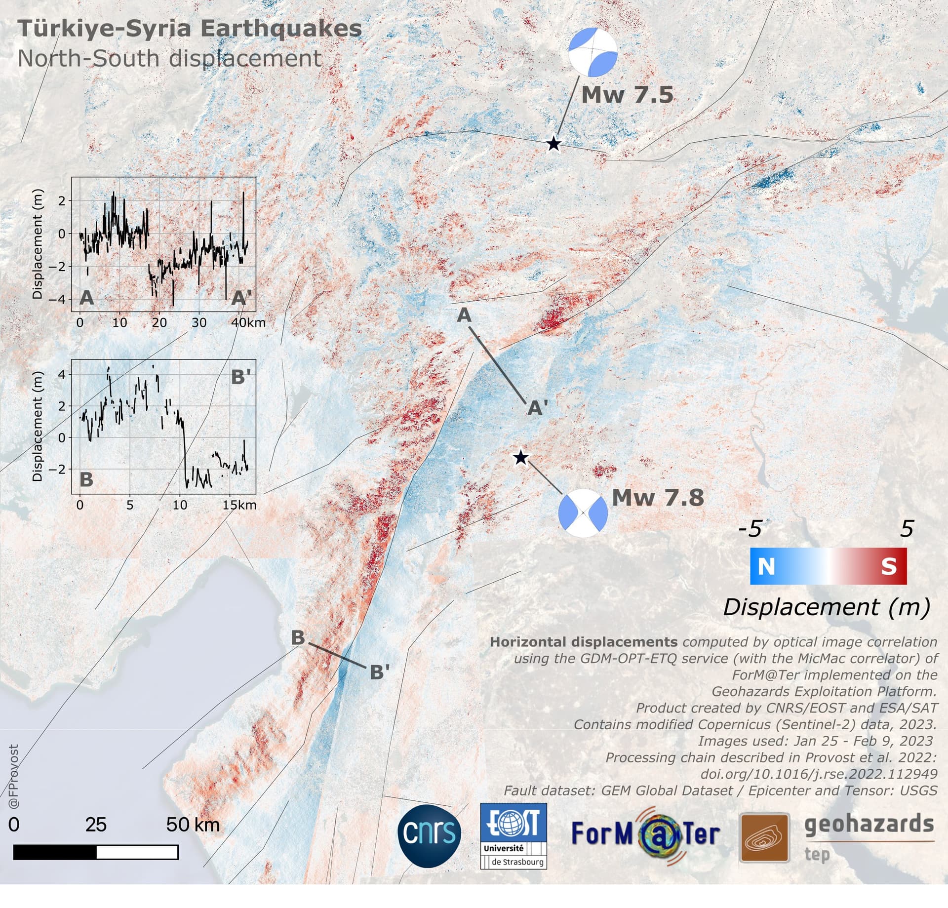
The current constellation of Earth Observation satellites allowed for rapid acquisition of the whole impacted area shortly after the mainshocks. On February 9, 2023, the Copernicus Sentinel-2 satellite captured a set of optical images while the region was mostly cloud free. This dataset offers a complete coverage of the system of faults activated during these events at 10 m spatial resolution. Although this resolution is not sufficient to map surface ruptures directly from the images, image correlation (also known as offset tracking) techniques can be applied on these images to retrieve the distribution of the surface displacement. The GDM-OPT-ETQ service of the ForM@Ter solid Earth data hub was used to measure the co-seismic displacement (with the open source photogrammetry library MicMac) between images of January 25, 2023 and February 9, 2023. The massive processing was performed on the Geohazards Exploitation Platform (GEP). The final products of the processing are East-West and North-South displacement maps covering an area of 300 km x 300 km at 10 m resolution. Spatial offsets in the range of 3 to near 10 m are identified with large geographic variability along the faults showing the extent of the activated faults. These maps significantly contribute to identify and map the ruptures of the Turkey-Syria earthquakes and determine the along fault displacement.
Merged products of the East-West and North-South displacements covering the entire area are publicly available for visualisation on the GEP.
The dataset can be downloaded in two file formats (kmz, geotiff, kml) on this page with the DOI 10.25577/ewt8-ky06
This work was realized by EOST for the SAT team and is supported by ESA, CNES and CNRS/INSU.