The Geohazards Exploitation Platform (GEP) is a cloud-based Earth Observation platform tailored for geohazard monitoring, terrain motion analysis, and critical infrastructure assessment. Operated by Terradue and funded by the European Space Agency, GEP hosts a wide range of processing services that empower users to transform EO data into actionable insights for science, operations, and disaster response.
With a growing community of over 3,200 registered users across research institutions, public agencies, and industry, GEP has become a central hub for EO-based geohazard services, offering both on-demand processing and systematic monitoring capabilities.
A Platform Purpose-Built for Geohazards
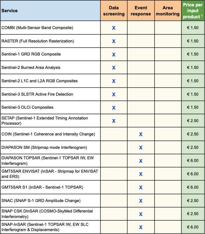
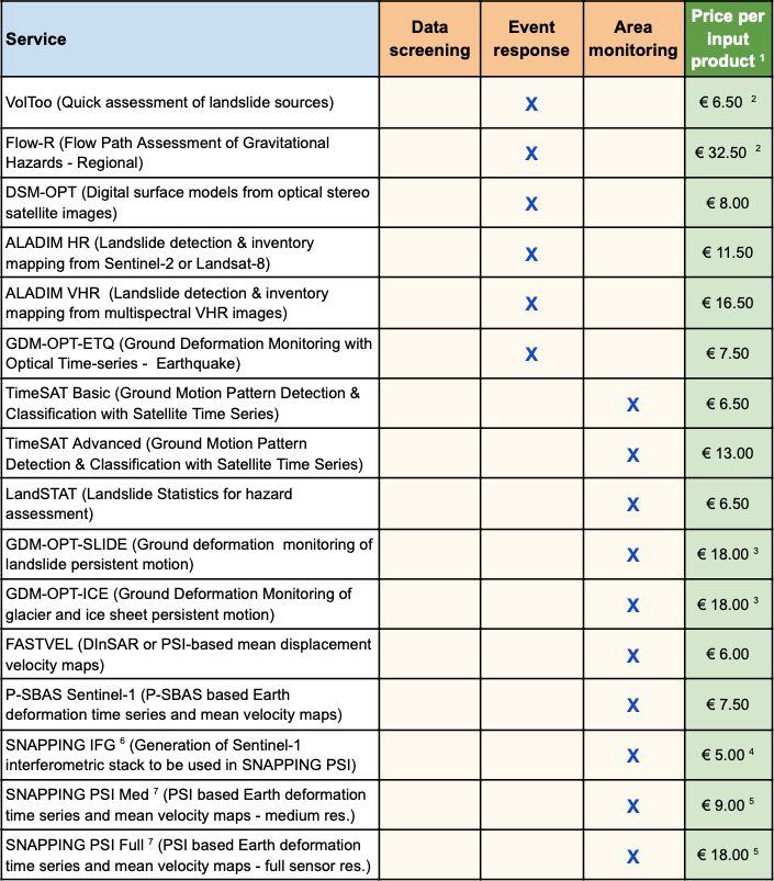
GEP offers more than 25 specialised EO services, including:
- Visualisation services for full-resolution and change detection imagery
- Advanced SAR and optical data processing, including:
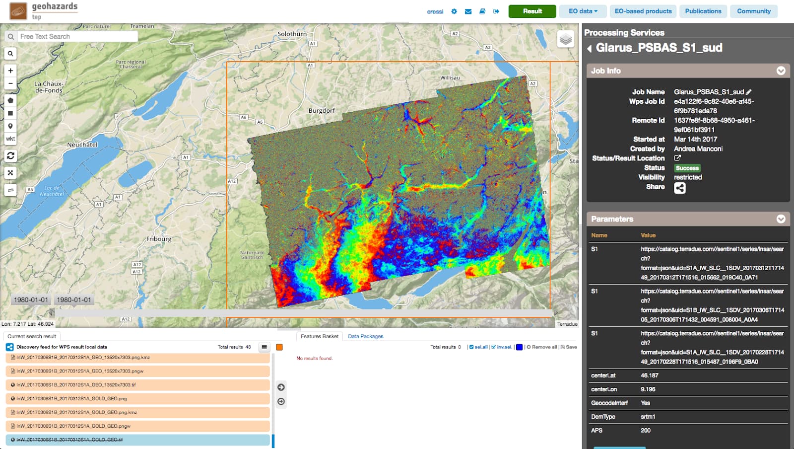
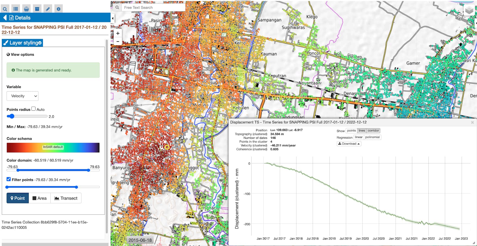
- Classic and advanced InSAR for Persistent Scatterers (PS) and Small Baseline (SBAS)
- Horizontal ground motion detection from optical time series
- Digital surface model (DSM) generation from stereo optical imagery
These services support a wide range of use cases such as volcanic activity tracking, subsidence analysis, earthquake response, and landslide detection. All services operate on cloud infrastructure, with access to over 400 TB of EO data, including Sentinel-1, Sentinel-2, Sentinel-3, ERS, ENVISAT, Landsat-8, SPOT, and Pléiades.
Designed for Users — from Research to Operations
GEP is designed for different user types:
- Researchers and scientists, who use GEP for pilot studies, validation campaigns, and long-term monitoring
- Public authorities and civil protection agencies, who rely on GEP for hazard mapping and disaster response
- Service developers, who can deploy their own algorithms using the EO Application Package model
Over 350 active contributors use GEP not only to run services but to publish new content and datasets. This enables collaboration and continuous service innovation.
Operational Models: Flexible Access and Sustainable Growth
GEP is offered under a Data-as-a-Service (DaaS) model with:
- Pay-per-use options for occasional users
- Monthly subscriptions for operational or intensive use
- Sponsored onboarding through ESA’s Network of Resources (NoR) program
The NoR sponsorship strategy helps new users—particularly from academia and public institutions—test the platform without initial cost. Many then transition into commercial users, reinforcing GEP’s sustainable service model.
Global Impact and Institutional Adoption
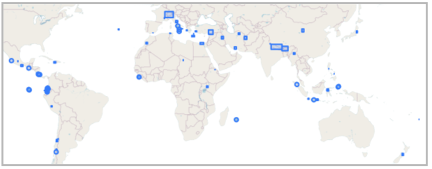
GEP is in use across multiple continents, including Europe, Southeast Asia, Africa, and the Americas. Highlights include:
| Title | Region | Description | Link |
|---|---|---|---|
| Central Chile Earthquake (September 2022) | Chile | GEP provided InSAR analysis to detect surface deformation and assess the earthquake’s impact on infrastructure. | Link |
| Santorini Volcano Unrest Phase (2023) | Greece | GEP services were used to monitor another phase of volcanic unrest at Santorini, one of the most iconic volcanoes in the Aegean Sea. | Link |
| Turkiye–Syria Earthquakes (February 2023) | Turkey - Syria | GEP facilitated the generation of interferograms and surface rupture mapping for the M7.8 and M7.7 earthquakes, supporting disaster response. | Link |
| Morocco Earthquake (September 2023) | Morocco | Radar interferogram generated using Sentinel-1 acquisitions to analyze the impact of the M6.8 earthquake. | Link |
GEP services are licensed to users in over 20 countries, supporting both local studies and international development projects.

Cloud Integration for EO Applications
Beyond pre-integrated services, GEP provides a dedicated application hosting environment:
- Users can package and deploy custom EO algorithms
- Integration support is available for onboarding new services
- Deployed services can be offered to other users via revenue-sharing agreements
This enables developers and organisations to scale up their applications, distribute them cost-effectively, and contribute to the broader EO ecosystem.
Real-World Utility: Event Response and Monitoring
GEP supports rapid response during disasters through its:
- Access to pre-processed EO datasets
- Automated services for event-triggered surface deformation mapping
- Visualisation tools for sharing results with stakeholders in real time
It also supports systematic data screening and long-term ground motion monitoring, contributing to operational resilience in critical infrastructure planning.
Explore and Contribute
Whether you’re a researcher looking to process Sentinel-1 data, a government agency planning hazard mitigation, or a developer ready to scale up your own EO workflow—GEP offers a flexible and proven platform.
![]() Learn more and register at https://geohazards-tep.eu
Learn more and register at https://geohazards-tep.eu
check also the platform guide or contact us