Background:
The increasing number and intensity of natural disasters in the past few years have had severe consequences in terms of human lives that were impacted, but also in terms of structural damage and economic losses. In years to come, extreme events will no longer be exceptions. Uganda is regularly affected by multiple natural hazards, including droughts, earthquakes, floods, landslides, and volcanoes. Flooding, particularly in low-lying areas, presents the largest risk. Each year, floods impact nearly 50,000 people and over $62 million in gross domestic product. Climate change is likely to increase average temperatures in Uganda up to 1.5 degrees Centigrade by 2030 and 4.3 degrees Centigrade by 2080. Rainfall variability and rising temperatures are expected to lead to higher incidences of droughts, water scarcity but also extreme weather related events which will likely increase population exposure to hydro-meteorological disasters such as heavy rainfall, floods and landslides (GFDRR 2017).
Geospatial information technology (GIT) including satellite imagery analysis and data visualization plays a vital role in understanding the geographic extent and severity of disaster events. Nevertheless, the ability of national and regional authorities as well as disaster management experts to seamlessly collect, integrate, analyse geospatial information in a comprehensible and easy to use format for remains a challenge that needs to be addressed with ad-hoc training and capacity development programmes.
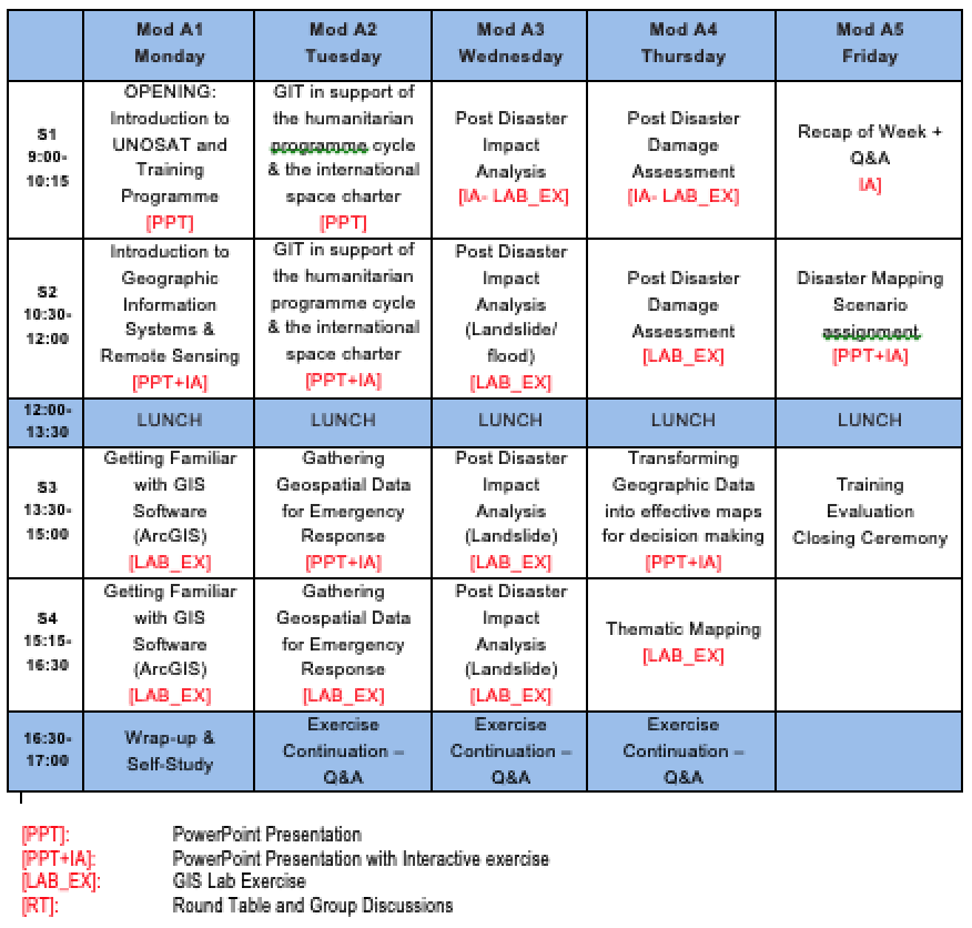
To meet these challenges, UNITAR-UNOSAT UNITAR-UNOSAT and UN Technology Bank are offering a 1-week introductory technical training course in the use of Geo-Spatial Information Technology to support operational planning and decision making for emergency response and post disaster recovery. This training will also include dedicated sessions on how to trigger satellite imagery acquisition mechanisms following major disaster events such as the International Charter Space and Major Disasters. The course is designed to accommodate selected participants from line ministries and national/regional disaster management authorities.
Learning Objectives:
The overall aim of this GIS course is to provide training participants with concepts and terminology of Geo-spatial Information Technology (GIT) including ad-hoc geospatial methodologies based on selected real case scenarios from previous disaster events in Uganda to support emergency response and recovery planning operations.
At the end of the course, participants should be able to:
- Define and describe basic concepts and terminology related to Geospatial Information Technology (GIT);
- Apply basic methods and functionalities of GIS software (ArcGIS) to manage and analyse spatial data;
- Explain the role of geo-information in the response / early recovery phase of a disaster;
- Identify suitable mechanisms for satellite imagery acquisition following major disaster events (e.g.
International Space Charter);
- Identify, search, collect, organize and analyse geospatial related information relevant for disaster mapping;
- Apply basic GIS methodologies to perform impact analysis and preliminary damage assessment in the aftermath of a disaster event;
- Undertake the process to create thematic maps for evidence based decision making in emergency response and post disaster recovery.
Software:
GIS lab exercises will be based on ESRI ArcGIS 10.7 with extensions (spatial analyst) or QGIS software, Google Earth. Internet access is required.
Class Size:
The number of participants is limited to 15-20 (max.) to ensure quality support provided by UNOSAT’s instructors.
Institutions:
UNOSAT - Operational Satellite Applications Programme (UNOSAT) of the United Nations Institute for Training and Research (UNITAR)
UN Technology Bank for Least Developed Countries
National Partners (Country Focal Point(s) and Hosting Institution(s) :
The Ministry of Science, Technology and Innovation (MOSTI
The Office of the Prime Minister (OPM)
Course Coordination:
Luca Dell’Oro, Senior Programme Specialist, UNITAR-UNOSAT (luca.DELLORO@unitar.org) – Overall Coordination
Romy Schlogel, Capacity Development and GIS expert, UNITAR-UNOSAT (romy.schlogel@unitar.org)
Rispha Gicheha, Capacity Development and GIS expert, UNITAR-UNOSAT (rispha.gicheha@unitar.org)